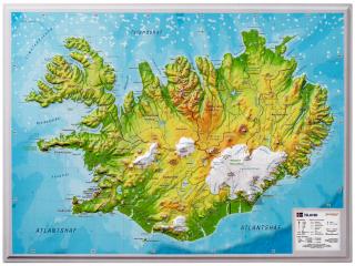
750 Island 2016 (Iceland) 1:500t mapa MICHELIN
Updated annually, MICHELIN National Map Icelandwill give you an overall picture of your journey thanks to its clear and accurate mapping scale 1/500,000. Map will help you easily plan your safe and enjoyable journey in Iceland thanks to a comprehensive key, a complete name index as well a clever time & distance chart. Michelin's driving information will help you navigate safely in all circumstances.
With MICHELIN National Maps, find more than just your way!
- Obchod: www.mapysveta.sk
- Zaradenie: EURÓPA | Island | automapy a autoatlasy
- Výrobca tovaru: Michelin
- Dostupnosť tovaru: do 504 hodín
- Aktualizované: 20.7.2024
- Cena: 9.99 Eur